
Burbank ZIP Coverage at a Glance
Official Burbank materials consistently use one postal code for City Hall and city departments. The nearby codes below are not extra Burbank service areas. They appear because Burbank meets Chicago, Oak Lawn, Bridgeview, and Bedford Park, and because regional searches often return close addresses from more than one municipality.
| ZIP | Area Covered | Post Office | Local Note |
|---|---|---|---|
| 60459 | Confirmed Burbank municipal addresses | Verify current station with USPS | Only code confirmed by official city materials |
| 60455 | Bridgeview and Oak Lawn area | Verify address with USPS | One delivery moved to 60459 in 2009 |
| 60453 | Adjacent Oak Lawn area | Verify address with USPS | Not confirmed for Burbank proper |
| 60456 | Adjacent Hometown area | Verify address with USPS | Comparison area only |
| 60638 / 60652 | Nearby Chicago postal areas | Verify address with USPS | Chicago postal lines do not prove Burbank jurisdiction |
The current station assignment for every 60459 delivery was not confirmed in the official pages inspected. The right source is the USPS ZIP Lookup for the full address. This Burbank ZIP code directory keeps that gap visible instead of guessing a post office name.
Burbank's 2009 Postal Switch
USPS Postal Bulletin 22257, dated April 23, 2009, documents a precise local change. It directs one delivery that had used 60455 to use the Burbank, Illinois 60459 last line. The bulletin also identifies Burbank as the 60459 place name. That fact can bridge an old letter, deed lead, or family file to a current mailing form.
This was a postal realignment. It was not a city annexation, parcel transfer, or deed change. Do not rewrite the older source. Record its original 60455 line, note the bulletin date, and add the normalized 60459 result as a second field. That preserves the history and gives modern portals a format they can match.
Note: The 2009 bulletin concerns a documented delivery change, not proof that every 60455 address once belonged to Burbank.
Search Burbank Within One ZIP
A ZIP code directory is a filter, not a household roll. Start by confirming one full postal address, then use that postal result to locate a public parcel or to check the searcher's own voter registration. Do not attempt to turn the five digits into a list of all people in the area.
- Enter the complete street, unit, city, and state in USPS ZIP Lookup. Save the returned last line and ZIP+4 when supplied.
- Search the Cook County Property Tax Portal with house number, street, optional unit, city, and ZIP. Record the PIN.
- Confirm the parcel in the Assessor or CookViewer, paying close attention to situs address, mailing address, municipality, and township.
- Use the Illinois voter tool only for the searcher's own first name, last name, birth date, and five-digit ZIP match.
- Once the area is down to a road, move to the Burbank street directory process for address-level records.
A failed result is a reason to check the spelling, unit, city label, and postal history. It is not proof that the parcel or person is absent from Burbank.
Burbank USPS Search Fields
The postal lookup has three distinct modes. Use the narrowest mode that fits the known data. By Address is the main tool for a parcel or old mailing line. By City and State checks a place label. Cities by ZIP shows the accepted city names tied to a code, but it cannot establish that a person or firm is physically present.
| USPS Mode | Fields | Best Burbank Use |
|---|---|---|
| By Address | Company optional; street required; apartment optional; city and state required; ZIP optional | Normalize one full address and obtain ZIP+4 |
| By City and State | City and state required | Check the postal place name |
| Cities by ZIP | Five-digit ZIP required | Compare accepted city names for a code |
USPS itself warns that its lookup does not prove a person or company occupies the address. In a Burbank ZIP code directory workflow, the result supplies mailing syntax. Cook County records supply the parcel and jurisdiction facts.
Map Burbank ZIP Boundaries
Cook County GIS publishes separate Address Points and ZIP Code Boundaries layers. That separation is useful. An address is a point, while a postal area is a polygon. Comparing the two can show whether the address text and the mapped ZIP agree without exposing any occupant.
The Cook GIS address and ZIP service offers service-layer attributes and JSON, GeoJSON, and PBF output. Its maintenance metadata describes the current service, not a dated history of residents or past postal boundaries.
The official service page shows the two layers used in this Burbank ZIP code check.
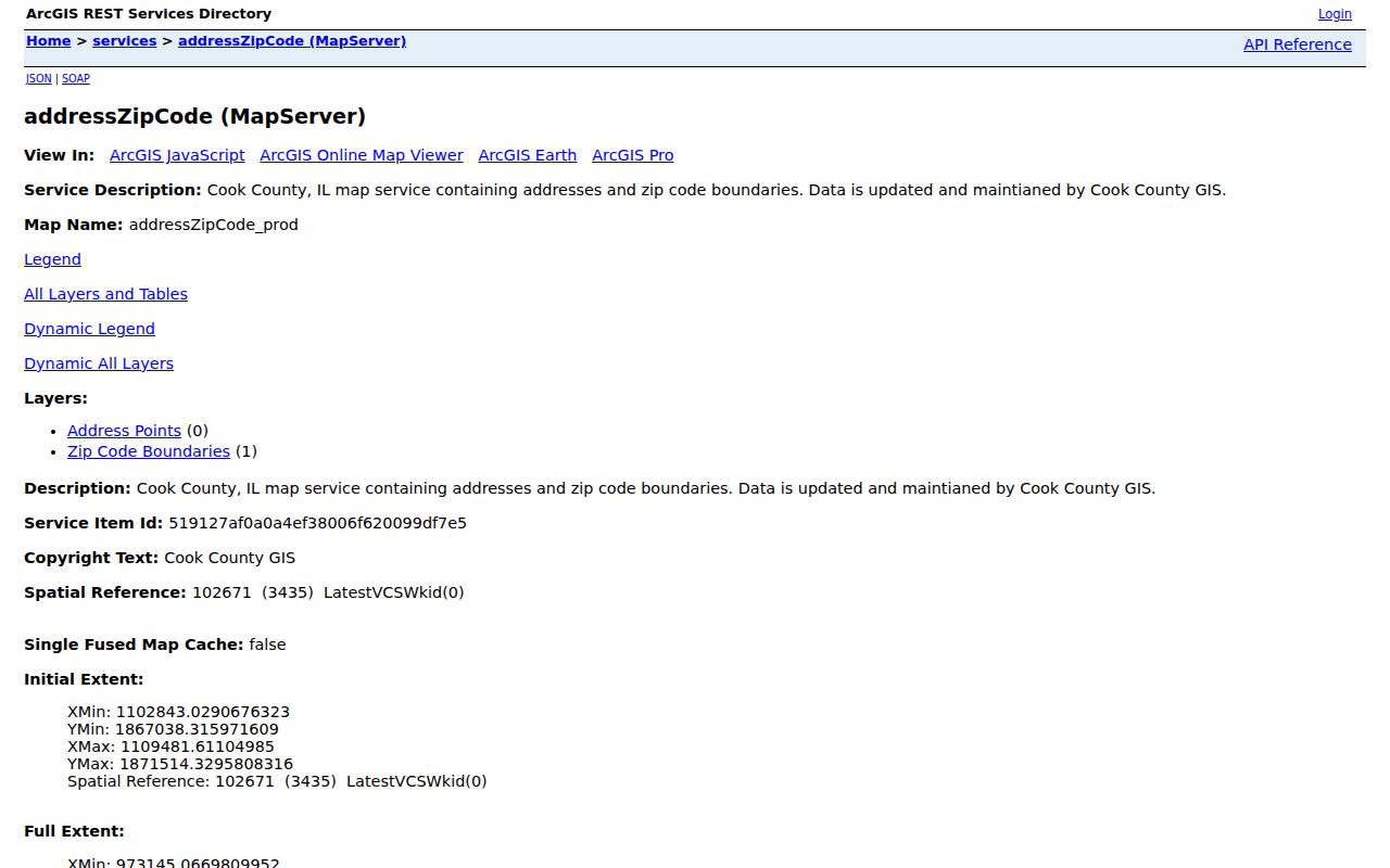
Use the map result to confirm geography, then return to the source record for names, dates, and scope.
Burbank ZIP Address Types
Cook County's record stack uses several addresses at once. The situs address describes the parcel's physical location. The tax mailing address is where a bill or notice goes and may belong to an owner, trustee, or agent elsewhere. A deed's legal description identifies land through subdivision, lot, block, and related terms. The 14-digit PIN connects these systems.
- ZIP and ZIP+4
- The five-digit postal area and a four-digit delivery segment added to a full address.
- PO-box ZIP
- A code used mainly or solely for post-office boxes rather than ordinary street delivery.
- Unique ZIP
- A code assigned to one high-volume organization or institution.
- Carrier route
- A group of delivery points served along one postal route.
- Situs address
- The assessor's location label for a parcel, which is not automatically a legal or postal address.
No PO-box-only or unique ZIP for Burbank was verified in the research. Those terms matter when reading USPS results, but they should not be invented as local facts.
Burbank ZIPs and City Limits
Burbank is bounded by Chicago, Oak Lawn, Bridgeview, and Bedford Park. Major corridors such as Harlem, Cicero, 79th, and 87th can place nearby addresses in different cities. A short drive or shared road name says nothing about municipal jurisdiction. Nor does the nearest commercial address settle which office keeps a record.
Boundary check. Keep postal city, incorporated municipality, Cook County, Stickney Township, ward, precinct, and parcel municipality in separate fields.
A Burbank address may carry 60459, Cook County, and Stickney Township at once. A nearby record can use another city or postal code while sitting close to the boundary. Check the ward map, parcel municipality, and address point before sending a City FOIA request or interpreting a court or voter district.
This mismatch is why a ZIP result does not prove residence. It identifies mail routing. The custodian's dated file provides the fact that matters for the search.
Older Burbank Postal Labels
Burbank incorporated on April 4, 1970. Earlier land, census, church, cemetery, and directory sources may use Stickney Township, South Stickney, a subdivision, or another regional label. The city history also traces farms, early subdivision plans, growth in the 1920s, and a large utility and sanitation build-out in the 1950s. Those eras explain why one modern city-and-ZIP query can miss an older person or parcel.
Preserve the address exactly as written, including its original street number, cross street, postal place, township, subdivision, and year. Then compare a deed, plat, map, directory, and dated newspaper. The 2009 60455-to-60459 change is a verified bridge. By contrast, no Burbank-wide E911 readdressing or complete street-number conversion table was found.
Do not apply Chicago's 1909 street-number conversion as though it were a Burbank event. Ask Burbank Building and Zoning or the proper Cook County GIS office about an unexplained local address change.
Burbank's Compact ZIP Scale
Census QuickFacts reports 29,439 Burbank residents in 2020 across 4.17 square miles, with 7,059.7 people per square mile. It estimates 9,539 households for 2020 through 2024. Those totals describe the city as a whole. They are not counts for each postal route, block, or address.
The scale explains why a citywide resident list would be a large, privacy-sensitive product rather than a simple ZIP code result. Aggregate facts are useful for context. To answer a question about one person or one parcel, return to dated official records and the correct municipal boundary.
Density also makes a loose map pin a poor match tool. CookViewer's address locator may place a point within roughly 100 feet, so confirm the PIN before linking it to a tax record. One parcel can contain more than one unit, and one mailing address can differ from the tax destination. The citywide Census count cannot resolve either issue.
Burbank's own history describes a mostly built-out residential city with retail corridors along Harlem, Cicero, 79th, and 87th. Postal searching near those roads can easily pull an adjacent municipality into the same result set. Check the complete street number and city line, not just the road name and five-digit code. This is where the compact scale helps: it gives context for close borders, while the parcel number and USPS result provide the exact check.
What Burbank ZIP Cannot Prove
A postal match cannot prove that an owner lives at the parcel, that every household member is named, or that a business operates at the address. A voter self-match confirms only the authorized searcher's own registration result. The tax portal finds parcels, not a ZIP-wide people list.
The Burbank ZIP code directory should end at the boundary of the evidence. Mark the source date, record the postal result, and distinguish the parcel location from the mailing line. If the address is protected, incomplete, or outside the custodian's scope, stop and use the lawful office route rather than trying to reconstruct private data.